
Walking Plan Concept in Summary
Execution of the continent walking.
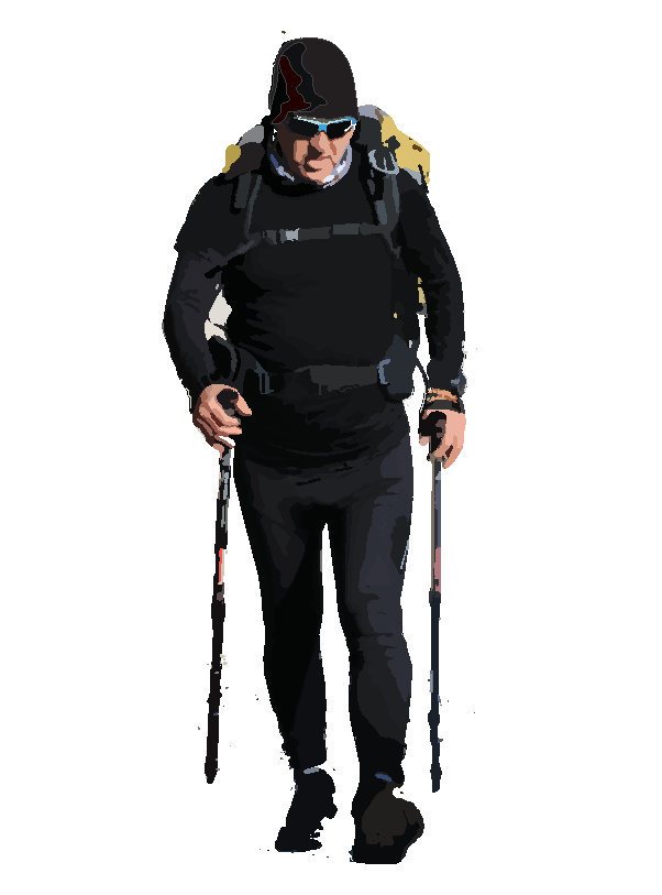
The plan is based on walking 25 to 38 kilometres per day for a total of 666 days. An additional 20 spare days have been allocated to accommodate unforeseen circumstances or emergencies. The entire journey will be completed solo, from start to finish.
Each day includes approximately 9 hours of walking, scheduled between 06:30 and 15:30. This timeframe may be adjusted depending on expected or unforeseen meteorological conditions. The planned walking speed ranges from 5.0 to 4.4 km/h, depending primarily on terrain and road conditions.
Equipment Transport Method
All required equipment and basic food supplies for the one-and-a-half-year journey will be carried in the hiking cart throughout the walk.
Route and Accommodation Plan
The route primarily follows the road network along the perimeter of the continent, excluding motorways. In rural areas, accommodation will mainly consist of tent camping, preferably at designated camping sites. Every four to five days, the plan includes staying in a guesthouse or regional hotel to rest and access proper hygiene facilities.
Nutrition and Food Strategy
Meals Ready-to-Eat (MREs) will be the primary source of nutrition throughout the journey. When available, these will be supplemented with fresh food. During accommodation stays, home-cooked meals may also be included as part of the nutritional intake.
Safety and Risk Management
A total of 53 Standard Operating Procedures (SOPs) have been developed based on the evaluation of 10 predefined security scenarios. These procedures have been finalised and are ready for operational use throughout the journey.

The Route
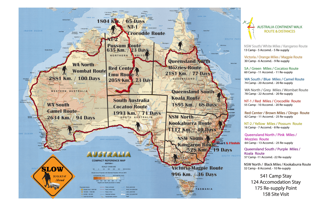
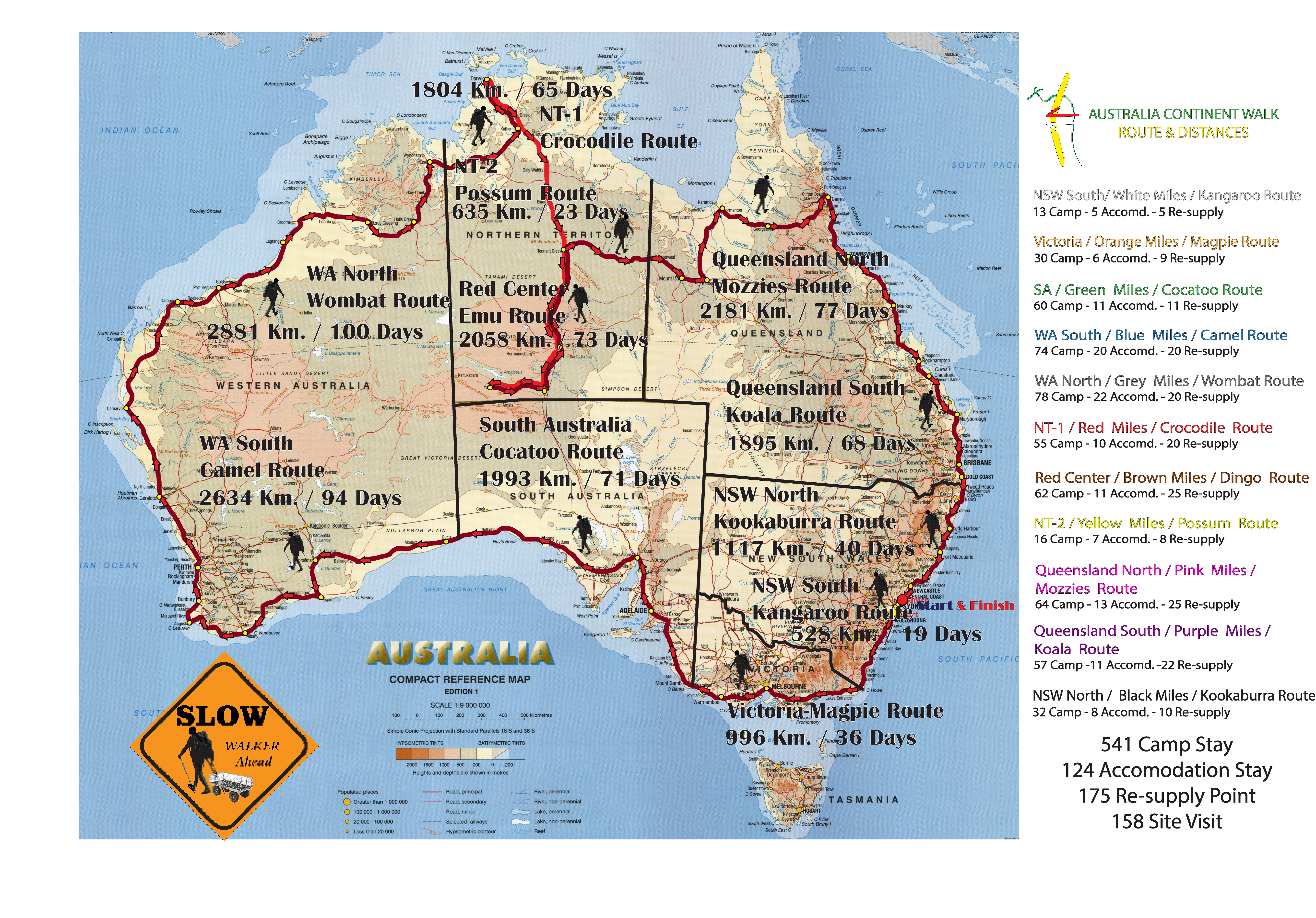
The planned route follows a clockwise direction around the Australian continent, starting and ending in Sydney. The route passes through the following key locations in sequence: Melbourne, Adelaide, Perth, Darwin, Alice Springs, Uluru, Tennant Creek, Cairns, Brisbane, and back to Sydney. The total distance of the route is approximately 18,725 kilometres.
Walking Distances
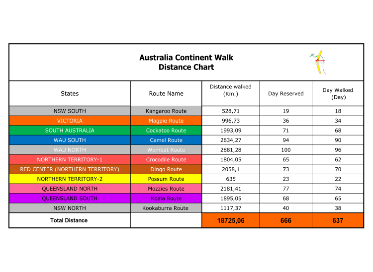
The total distance of the Australia Continental Walk is 18,725 km (11,635 miles). The route is divided into 11 sub-routes, each with its own seasonal and geographical factors affecting walking conditions. Among these, seasonal elements are the most critical and have been carefully accounted for in the planning process.
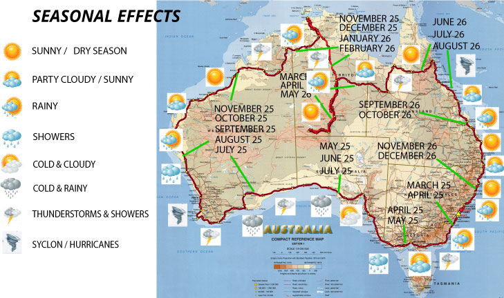
Seasonal Elements & Effects

To accurately identify key seasonal factors that may impact walking conditions, I analysed the seasonal effects for each state. These effects have been categorised into three main groups: red, yellow, and blue.
The red category includes cyclones, tornadoes, forest fires, floods, intense lightning, and severe thunderstorms. These conditions are expected to cause walking delays of seven days or more.
The yellow category includes monsoon-style heavy tropical rains and extreme cold conditions. These factors are expected to cause walking delays of approximately 4 to 6 days.
The blue category includes rainy conditions, infrequent lightning and thunderstorms, high wind events, and hot weather with a high UV index. These conditions are expected to cause walking delays of one to three days or more.
The South Australian crossing will occur under cold and stormy conditions; however, no significant walking delays are anticipated. The route along the southern and western coasts of Western Australia will encounter lightning storms and intense cyclones, potentially causing short-term delays of 5 to 7 days. The Northern regions of Western Australia, Darwin, and the Northern Territory will be subject to extreme heat, tropical rains, flooding, and heavy lightning storms, which may result in delays of 7 to 10 days. Northern Queensland will be traversed in hot and dry conditions, while southern Queensland and northern New South Wales will experience mild and rainy weather, with no expected delays in these sections.
